I. SUMMARY INFORMATION
Project
267443
Status
Submitted
Award category
Products and life style
You want to submit
NEW EUROPEAN BAUHAUS AWARDS : existing completed examples
Project title
Territoriotipo
Full project title
Territoriotipo - surfaced culture
Description
Territoriotipo uses advanced technology and open data to physically represent the landscape at the highest resolution possible. The aim is to help people love and protect our mountains through knowledge: whether it be a small scale 3d object to put in your house or a really large model inside a museum, you can now touch and experience the territory in an unprecedented way and learn how to protect it.
Where was your project implemented in the EU?
Italy
Veneto
via delle industrie 9
Venice
30175
When was your project implemented?
Has your project benefited from EU programmes or funds?
No
Which programme(s) or fund(s)? Provide the name of the programme(s)/fund(s), the strand/action line as relevant and the year.
II. DESCRIPTION OF THE PROJECT
Please provide a summary of your project
Territoriotipo was born to stimulate the awareness that we are part of one whole environment and does so using the modern technology to portray the mountain landscape in a unique way. The mountain subject has been chosen because mountains in all cultures have a spiritual meaning and are a symbol of the power and beauty of nature.
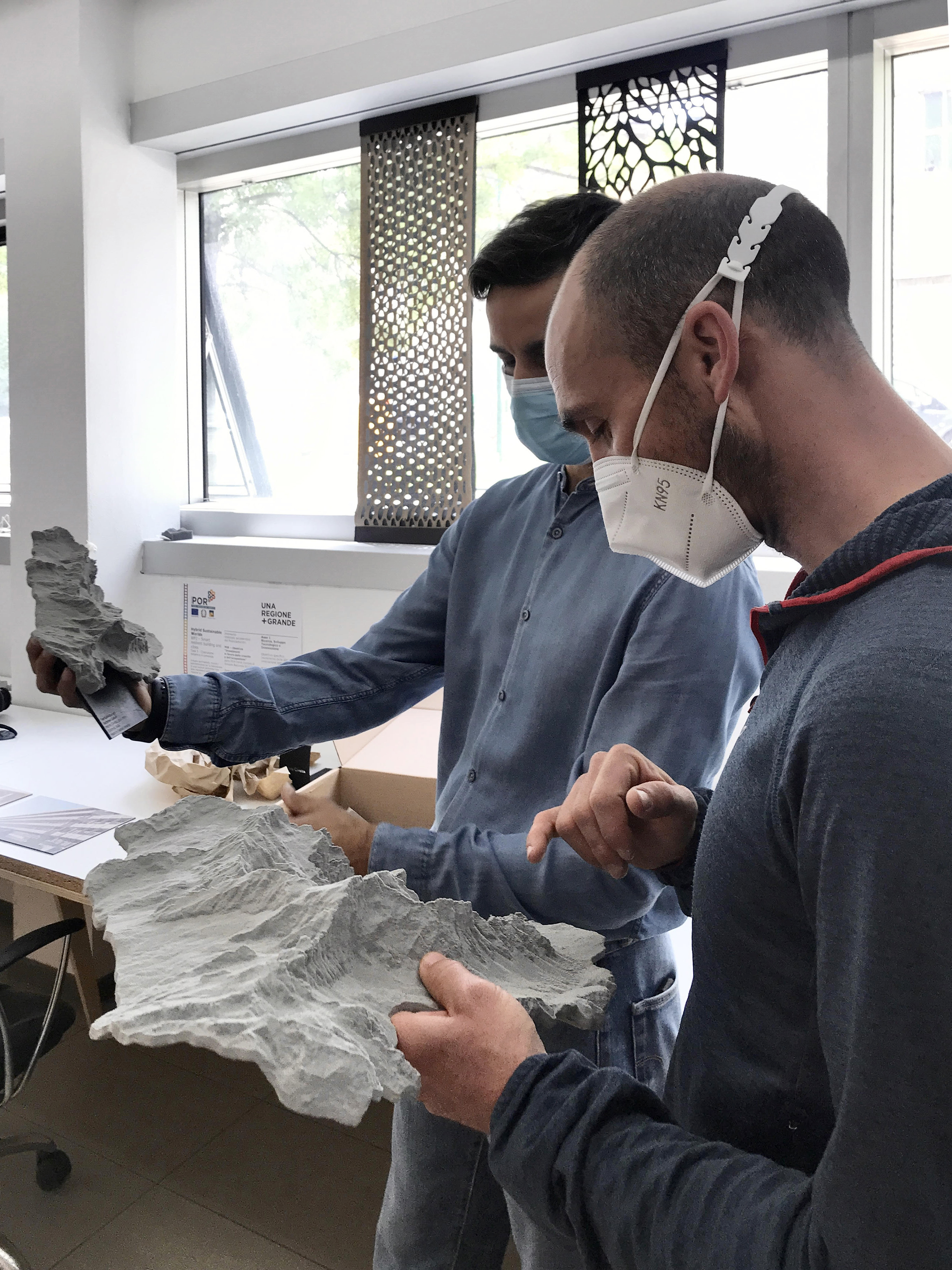
The projects has been created and developed by Fablab Venezia, a digital fabrication lab based in the ourskirts of Venice which aims at spreading the digital culture and uses CNC technologies such as 3d printing to help designer, enterprises, cultural institutions and citizenship develop their ideas and projects. The lab decided to pay homage to the natural landscape developing a new set of objects an processes that use advanced technology to build a sustainable meaningful business.
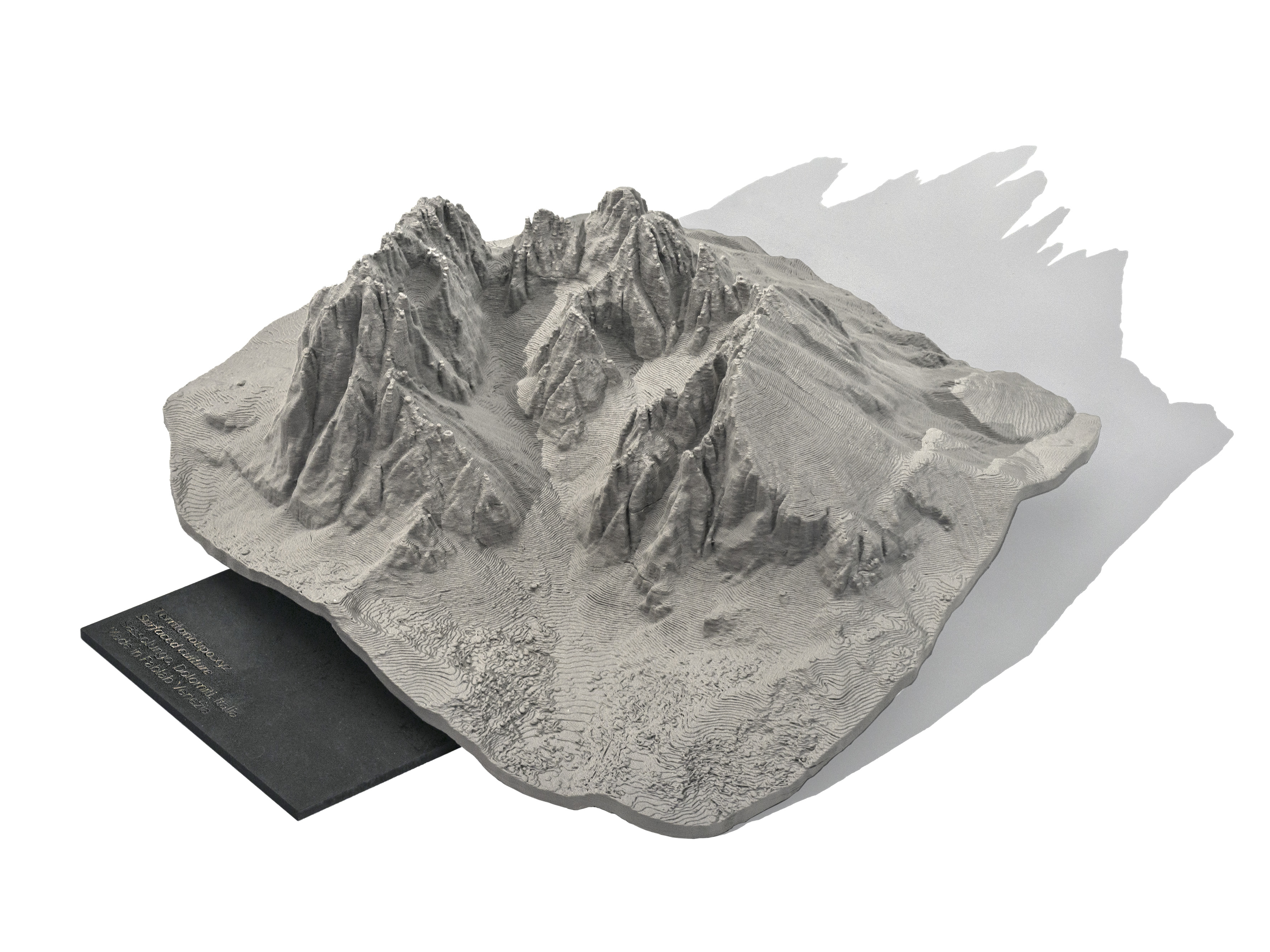
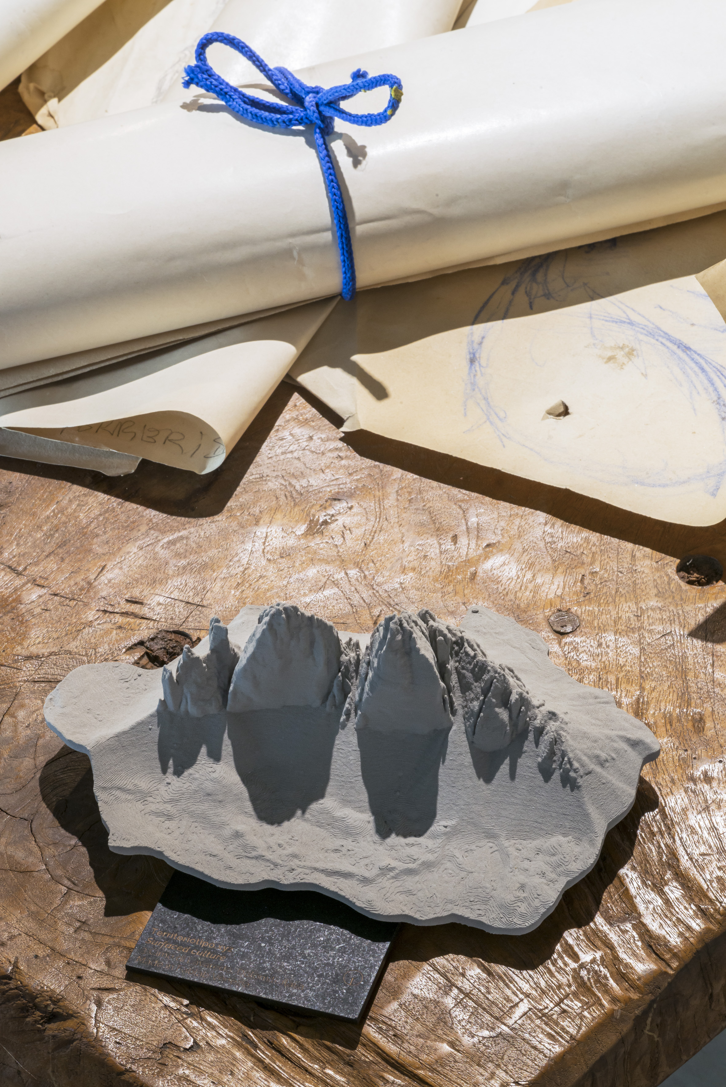
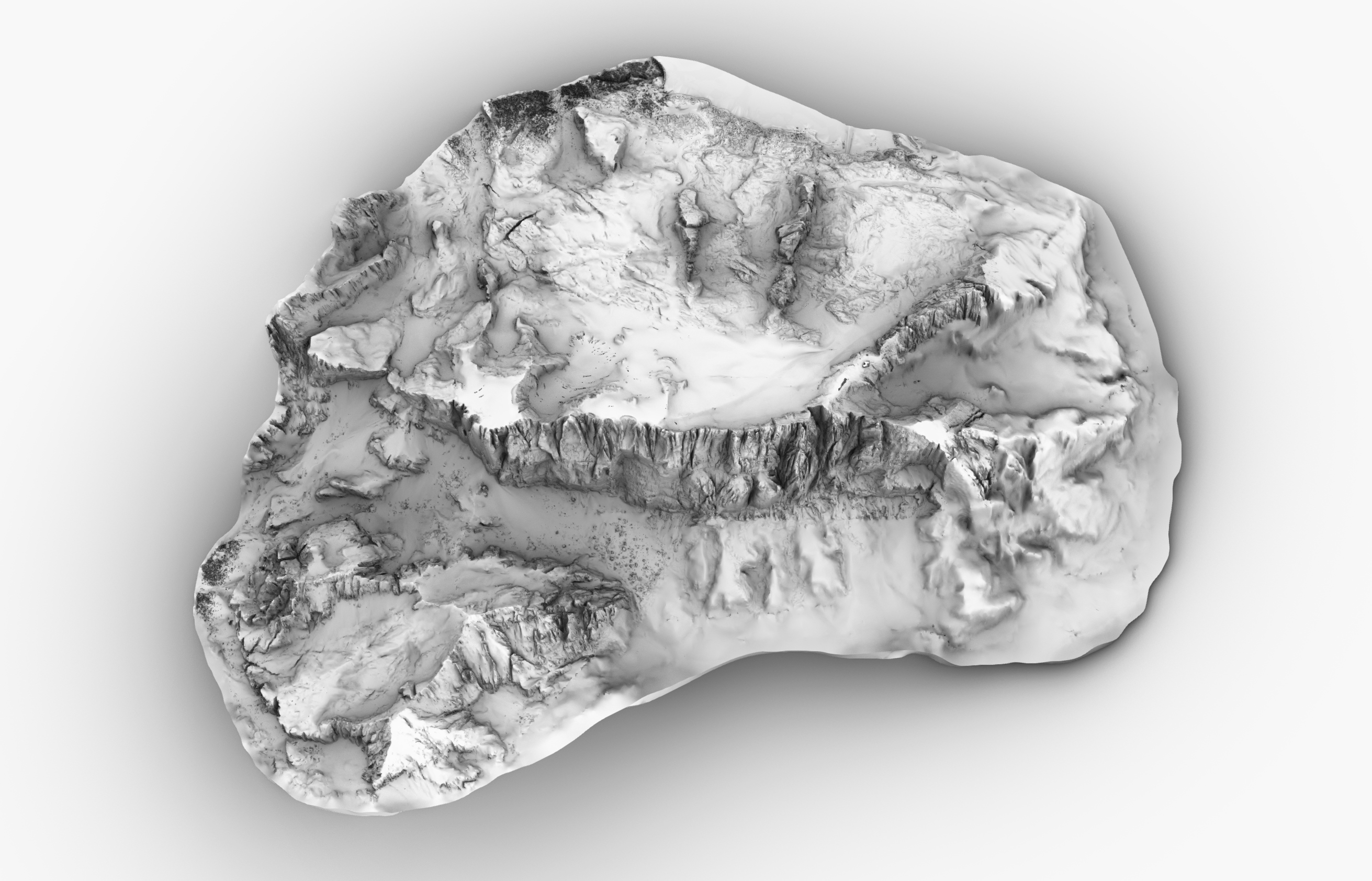
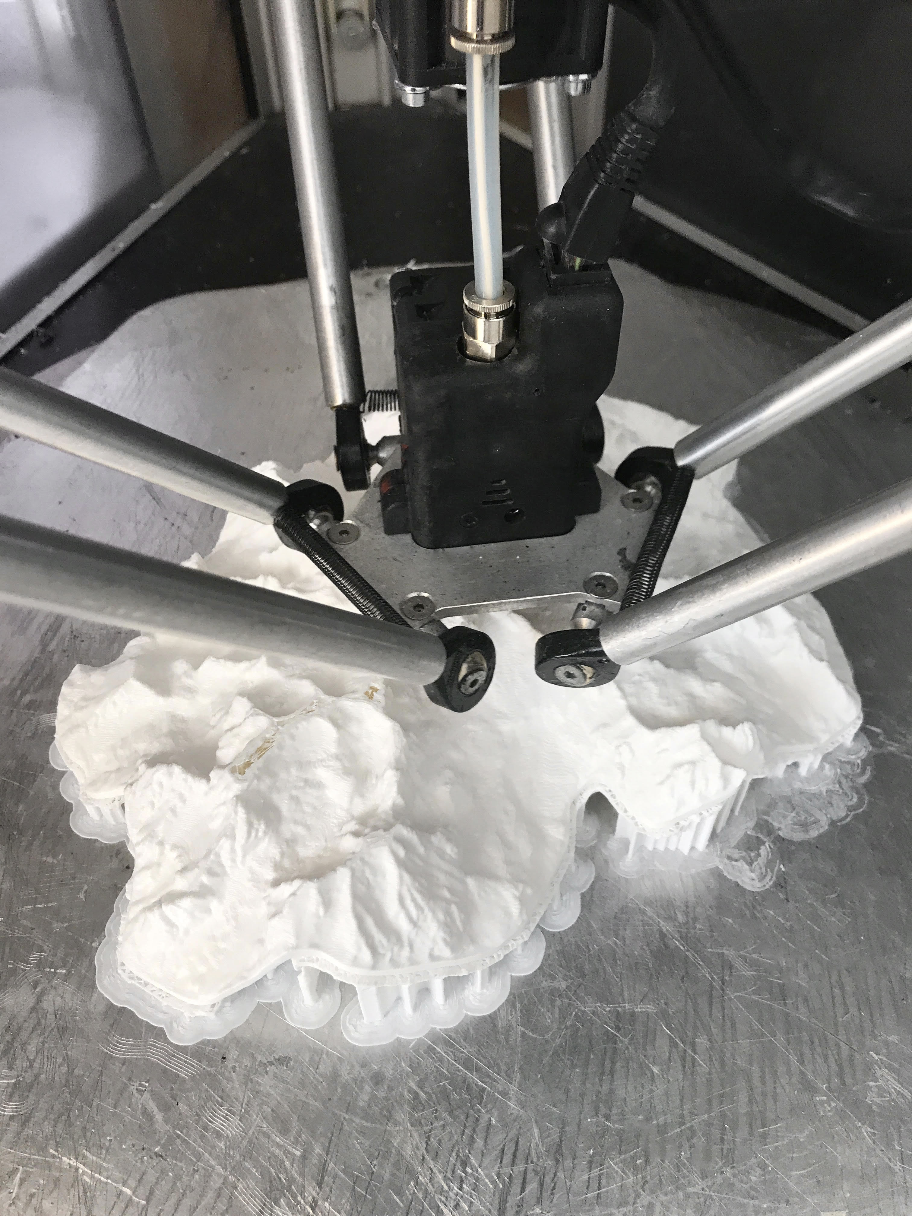
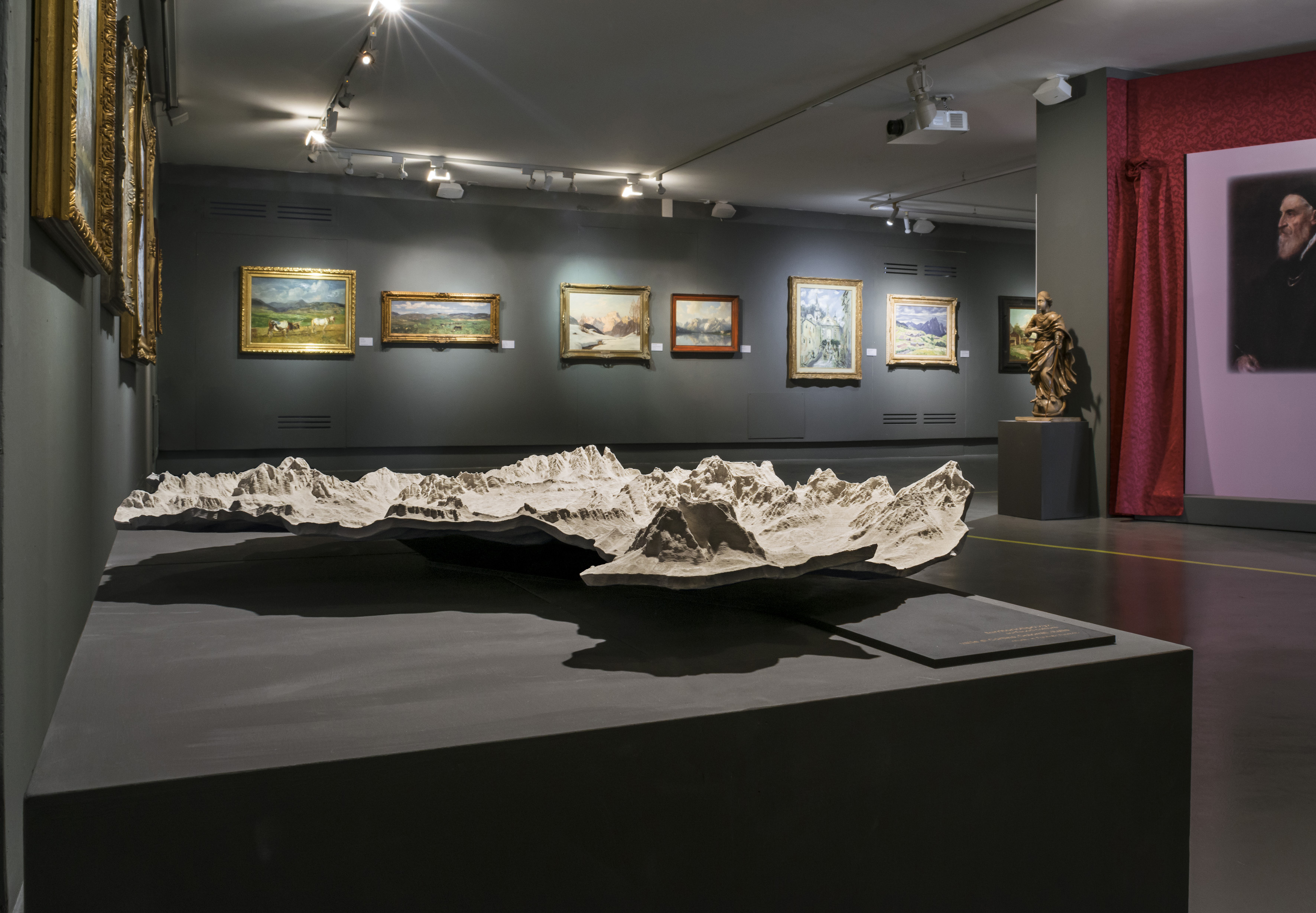
The products are 3d models that use the highest resolution existing data of the morphology of the territory to produce physical 3d models through 3d printing. Each model is generated from raw cloud points, 3d printed using only PLA bioplastic, then manually post produced using water based varnishes plus dolomia powder. The result are highly impressive 3d models that reproduce the most beautiful peaks and valleys of the Alps (but hopefully the representation will be extended to the rest of the world) at different scales and dimensions.
All the models are produced using additive manufacturing and on demand, to reduce the waste end se of resources, the 10% of each purchase goes to local projects of valorization and safeguard of the environment.
Please give information about the key objectives of your project in terms of sustainability and how these have been met
Territoriotipo is actively oriented towards sustainability both as concerning the productions and its grounding values.
We decided to use the technology we have to develop a digitally-artisanal product that could be as environmentally aware as possible: we use bio based material: the model is 3d printed using polylactic acid polymers, the support basis is laser cut in wood, the varnished are water based, we try to rely on local/national suppliers as much as possible.
The digital fabrication technology we use allow us to have a sustainable production process, as we produce only what and when we need, 3d printing minimizes the waste material and laser cutting makes it efficient to quickly produce all the complementary parts we need by ourselves.
We donate 10% of all the sells to environmental projects, this helps us support valuable initiatives that aim at protecting the environment.
The overall goal of the project is to help people become more aware, loving and respectful of the environment they live in, so that they will became more environmental responsible too.
Please give information about the key objectives of your project in terms of aesthetics and quality of experience beyond functionality and how these have been met
We wanted to create products that are informative and beautiful, object of affection but also with a educational aim.
3d printing, mostly used for prototyping, can actually have some aesthetic value in itself, and the layers remind of level curves. Each model/mountain has been carefully modeled from the raw data and we decided not to cut the perimeter straight, with vertical walls; instead we modeled them to let the mountain sort of float and be detached from the horizontal surface.
Using a gray varnish with stone powder in it was a precise choice to give materiality but also not to interfere with the sculptural value of the mountains with colors. We also choose not to represent any anthropic object, to leave untouched the image of the natural landscape.
Please give information about the key objectives of your project in terms of inclusion and how these have been met
Through the project we have been establishing contacts and collaborations with authorities, institutions and museums, the goal is to realize larger models that can be made available to the public with an educational aim. We are strongly convinced that the physicization of the data help people understand better how the territory is shaped, establishing a deeper connection with it and therefore be willing to protect it.
We also started a beautiful and interesting dialogue with the local association for blind and vision impaired people (Unione Italiana Ciechi e degli Ipovedenti): we brought them some models to touch and listened to their feedback, which led us think that this kind of physical device could be a very useful support to let them immagine the outer world in a new way. We are now planning to strengthen the collaboration and develop some new projects.
Please give information on the results/impacts achieved by your project in relation to the category you apply for
The project is still young but, in addition to the positive feedbacks and appreciation we have received from people and customers who have bought or seen the models, we are particularly satisfied by the fact that museum and institutions have understood the potential of 3d printing and new technology for the realization of educational supports in a quite economic and very detailed way. One model, representing the Ampezzo Valley, has been included in one exposition in Cortina d'Ampezzo and it currently forms part of the local paleontologic museum.
Speaking about impacts it is also very important for us to notice that the 10% of the income will be always give to environmental preservation an valorization project, thus broadening the positive impact of the project.
Please explain the way citizens benefiting from or affected by the project and civil society have been involved in the project and what has been the impact of this involvement on the project
The project has not been developed through the help of the community but is strongly bound with the idea of giving back to the citizens.
The project starts from open data, which are free and provided by local authorities, and tries to make them truly available to the public by materializing them. 3d cartography data are open information which are nevertheless very difficult for people to access, manipulate and understand. Through complex and long elaboration we proceed to transform the raw data (point clouds) in a virtual/physical model that can be seen and understood from everyone. For some parts of the territory it has been necessary to put together data from different authorities (trans-regional or trans-national, for example for the Pale di San Martino, the Matterhorn, the Mount Blanc) and this, tough been quite time consuming, is a beautiful occasion to give back to the citizens informations that they hardly could experience by themselves.
Please highlight the innovative character of the project
It is probably the first time that cartography data are processed and translated into understandable 3d outputs with such a high definition and with a public aim. Each model requires more or less a week of work, starting from the raw data (usually Lidar flights, which is an advanced and very high definition way to scan the territory) to achieve the final digital model. Each file needs to be carefully explored to find eventual glitches, transformed into surfaces/meshes, and then refined and made suitable for 3d printing; the overall process needs specific technic skills.
For us, the project is also innovative in its willingness to merge advanced technology and artisanal process: we decided to post-produce every model manually, filling them a little with water-based resins, and varnishing them with stone/dolomia enriched varnishes.
Please explain how the project led to results or learnings which could be transferred to other interested parties
The overall process shows, to us, a meaningful use for the open data and a best practice of how to give back to the citizens information that they already namely own and pay for, but that are difficult to access and understand. New technology facilitate this re-appropriation and well show the educational value that such data can have.
Moreover, it is important for us to underline that business projects (Territoriotipo is actually a product/service project, it includes a profit aim) can and should be grounded in deeper reasons than the mere economical reason. Nowadays we can not avoid to include sustainability an social responsibility in our business models.
Is an evaluation report or any relevant independent evaluation source available?
No
III. UPLOAD PICTURES
IV. VALIDATION
By ticking this box, you declare that all the information provided in this form is factually correct, that the proposed project has not been proposed for the Awards more than once under the same category and that it has not been subject to any type of investigation, which could lead to a financial correction because of irregularities or fraud.
Yes